
BRITS are bracing for heavy rain and 70mph gusts as stormy conditions look set to sweep across the UK this week.
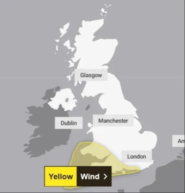
The Met Office has issued a of England and Wales for Friday. Here’s what we know so far.

Is Storm Austen coming to the UK?
The approaching low-pressure system has , and its exact path remains uncertain.
Forecasters are tracking a deep area of low pressure which could cross Britain overnight on Thursday and through Friday.
If it is named by the Met Office, Ireland’s Met Eireann or the Netherlands’ KNMI, it will be called Storm Austen.
It would be the first storm named under the .
The name honours Austen Nagle, the first director of the Irish Meteorological Service.
are generally named when significant disruption is expected, typically prompting an amber or red weather warning.
When will Storm Austen hit the UK?
The strongest winds are expected in the early hours of Friday with a yellow weather warning in force from midnight until midday that day.
Gusts of 50-60mph are possible across affected areas, potentially reaching 70mph or more in exposed coastal locations.
But the added that “there is uncertainty in where the strongest winds will be”.
The agency’s deputy chief forecaster Tom Crabtree said: “An area of the forecast we’re particularly focusing on is the development of a potentially deep area of low pressure that could cross the UK overnight on Thursday and through Friday.
“It has the potential to bring some strong winds, though the location of the strongest winds will be determined by the low position.
“At this stage, people should keep an eye on the and be prepared for some unsettled weather at the end of the week.”
If the system travels further south, France could face the worst conditions instead.
While a more northerly track could change which parts of the UK are affected.
Where is the Met Office weather warning?
The yellow wind warning covers 38 local authority areas across southern Wales, southwest England, parts of the southeast and Herefordshire.
The full list of affected areas is as follows:
London and South East England
- Brighton and Hove
- East Sussex
- Hampshire
- Isle of Wight
- Portsmouth
- Southampton
- West Sussex
South West England
- Bath and North East Somerset
- Bournemouth, Christchurch and Poole
- Bristol
- Cornwall
- Devon
- Dorset
- Gloucestershire
- Isles of Scilly
- North Somerset
- Plymouth
- Somerset
- South Gloucestershire
- Torbay
- Wiltshire
Wales
- Blaenau Gwent
- Bridgend
- Caerphilly
- Cardiff
- Carmarthenshire
- Ceredigion
- Merthyr Tydfil
- Monmouthshire
- Neath Port Talbot
- Newport
- Pembrokeshire
- Powys
- Rhondda Cynon Taf
- Swansea
- Torfaen
- Vale of Glamorgan
West Midlands
- Herefordshire
The Met Office warns that flying debris and large waves could pose a small danger to life, while roof tiles may be dislodged and power supplies disrupted.
Road, rail, air and ferry journeys could face delays or cancellations, with some roads and bridges potentially closing.
Heavy rain could make travelling even more difficult.
Residents are advised to secure garden furniture, bins and trampolines, while those visiting the coast should avoid exposed seafronts during high winds.
What is the UK weather forecast this week?
More unsettled is expected before Friday’s possible .
Rain will move north across much of Britain overnight and .
Northern Ireland and southwest England should see some brighter spells before another band of rain moves in from the west on Tuesday evening.
The rain is expected to gradually clear eastwards across the through Wednesday, although further showers are forecast, with strong winds in parts of eastern and southeastern England.
Thursday brings the possibility of heavier rain and gales before Friday’s strongest winds.
into Saturday, before another Atlantic weather front brings milder temperatures and more rain.
The Met Office advises checking its latest warnings before travelling, particularly on Friday morning.