TEMPERATURES are set to plummet as a significant cold plunge and 90mph winds are forecast to grip Britain over the Easter weekend.
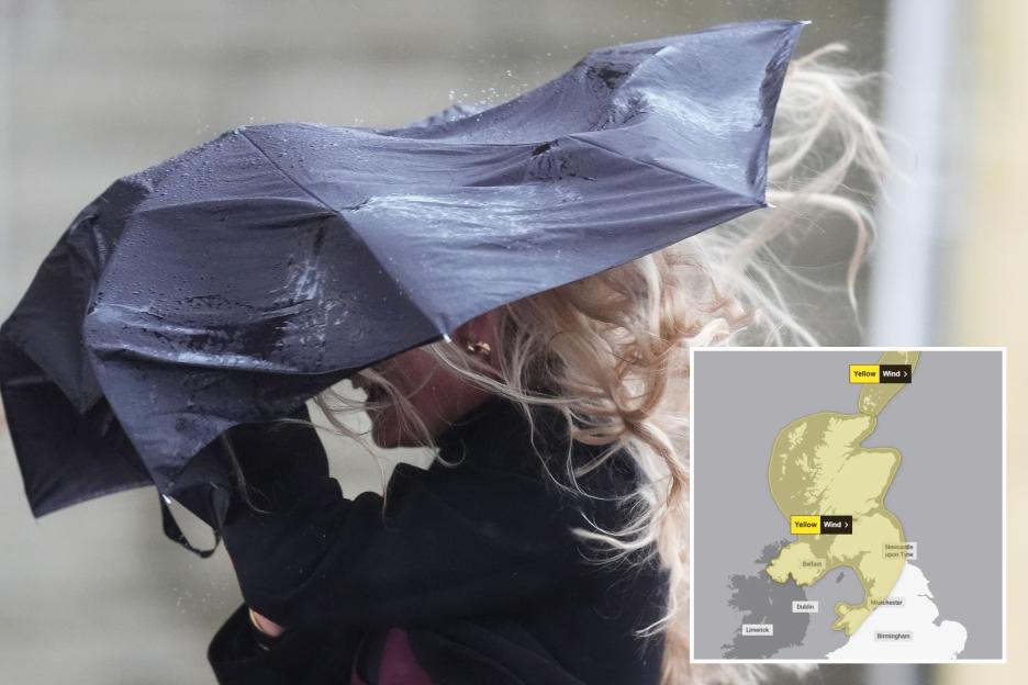
The has issued a yellow warning for strong winds covering , and parts of and Northern .
 Chilly temperatures will grip the nation on SaturdayCredit: Alamy
 Strong winds are expected over the weekend with potential for frost covering some regions as temperatures plummetCredit: Alamy
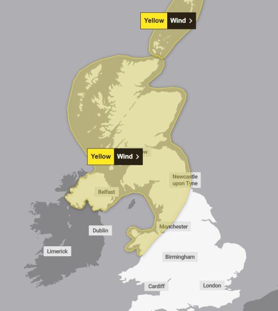 A yellow weather warning for strong winds has been issued across the North of the countryCredit: MET Office
It comes into force on Saturday and will remain in place across the Easter weekend until Sunday.
Gusts of 50-60mph are expected to batter the UK with stronger winds potentially reaching speeds of 60-70mph in exposed locations.
In western parts of windspeeds could reach 80-90mph, the forecaster said.
Amid the fierce winds and chilly temperatures, Brits have been warned to expect some rail, air and ferry travel delays with potential for cancellations.
Some roads and bridges could close with high speeds posing a risk to high-sided vehicles.
The Met Office has also warned the strong winds pose a potential risk of power cuts and damage to buildings.
According to the forecaster, there is a “small chance” of injuries as a result of large waves and beach material being thrown onto sea fronts, coastal roads and properties.
Met Office Deputy Chief Meteorologist Dan Holley said: “A significant cold plunge from into the North Atlantic will impact our weekend weather, strengthening the jet stream and spinning up a deep area of low pressure towards the northwest of the UK on Saturday night.
“This will lead to a spell of very strong winds later on Saturday, and overnight into the morning of Easter Sunday.
“We have issued yellow warnings for wind for Scotland, , and northern parts of both and for Saturday night and into Sunday, when a spell of very strong winds could cause disruption.
 Wind speeds could reach 80-90mph in some parts of the countryCredit: PA
 Light showers are expected across most of the UK with heavier downpours in some areas a possibilityCredit: Alamy
“Winds should gradually ease through Easter Sunday as the area of low pressure clears to the North Sea.
“Gusts are expected to reach 50-60 mph widely, with 60-70 mph possible in exposed locations.
“There is a chance of very in the west of Scotland, where gusts of 80-90 mph could be possible.
“Due to the warnings this weekend, we recommend keeping an eye on our latest forecasts and as the week progresses.”
Temperatures took a plunge last night, reaching as low as -5C in some rural areas and bringing .
Today, slightly colder temperatures will remain as wind and rain move north-west across the country as the day goes on.
As the Easter weekend approaches some rain and cloudy weather is expected with showers set to fall across the nation on Good Friday.
These could turn heavy in some areas, the has warned.
Over Friday night, colder air will move with temperatures plummeting overnight and into Saturday morning.
Frost is expected in some areas across the Easter weekend with strong winds accompanying the .
Met Office 5 day weather forecast
Today:
Cloudy at first in the far southeast with light rain or drizzle, soon clearing.
Mostly dry elsewhere with sunny spells. Cloud and rain spread into the northwest later, snow on Scottish hills, turning windy with possible coastal gales. Average temperatures.
Tonight:
Cloud, rain or drizzle moves southeastwards, reaching most areas by dawn, though the far southeast staying dry.
Snow affects Scottish hills. Increasingly windy with possible northern coastal gales.
Friday:
Rain spreads southeastwards, which can be heavy on western hills. Brighter, showery weather follows in northern Scotland.
Windy for many, with gusts near high ground. Mild in the south, colder in the north.
Outlook for Saturday to Monday:
Rain spreading north with strong winds and gales in the north-west. Sunshine and showers on Sunday, still windy in the north.
Mostly dry on Monday before rain reaches Northern Ireland later.

Eze Chidiebere Paul
I'm dedicated to creating high-quality content that informs, inspires, and delights. If you have any questions or suggestions, don't hesitate to get in touch. Happy reading!