A MAP has revealed where Storm Amy will batter the UK with heavy rain and 80mph winds this weekend.
The earlier issued a 30-hour weather alert across large parts of Britain in anticipation of the first named storm of the season.
 Storm Amy will batter the UK this weekend
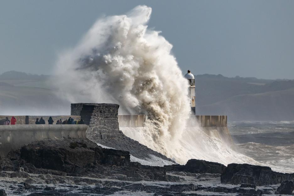 Waves crash against the harbour wall on September 15 in Wales
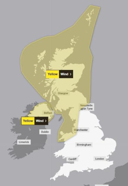
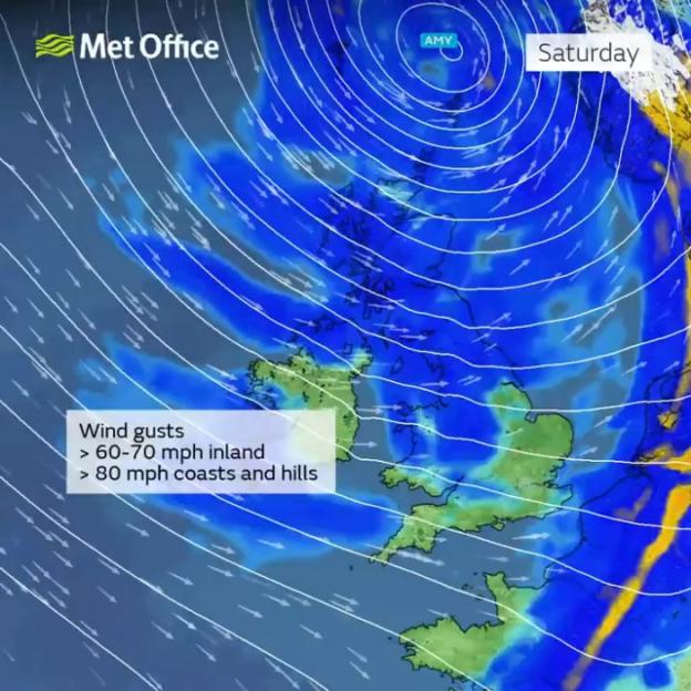 A Met Office map detailing the weather prediction for the weekend
A yellow weather warning for wind comes into force at 6pm on Friday and lasts until 11.59pm on Saturday.
It covers the whole of Scotland and stretches down to Manchester.
There is a second alert over Northern Ireland which comes into force earlier from 4pm on Friday and ends at 6am on Saturday.
Those affected have been warned to expect some damage to buildings, such as tiles being blown from roofs.
Strong gales may also spark power cuts, with the potential to affect other services, such as mobile phone coverage.
Injuries and danger to life from flying debris are also possible, the Met Office warned.
Brits living near the coast have been urged to stay safe amid “large waves and beach material” being thrown onto sea fronts.
Meanwhile travel on public transport services is likely to be disrupted with delays and cancellations.
Ahead of Storm Amy, a yellow rain warning is currently in place over western Scotland throughout today and tomorrow.
A further 30 to 50mm of rain is expected to fall over hills and mountains, with as much as 60 to 80mm over west-facing high points from late Wednesday through to Thursday night.
UK 5 day weather forecast
Today
Turning more unsettled through the week.
Often cloudy across Scotland, Northern Ireland and northern England, with outbreaks of rain.
The rain heavy at times in the west.
Further south, remaining dry with patchy fog returning to the countryside under any clearer skies.
Thursday
Widely cloudy in the north and west with rain becoming widespread and heavy by the afternoon.
Dry in the southeast with some sunshine, before cloud builds from the northwest later.
Outlook for Friday to Sunday
Briefly settled Friday morning, ahead of Storm Amy moving in from the Atlantic.
Turning widely wet and windy.
Windy throughout the weekend too, with a mixture of sunshine and showers.
A Met Office spokesperson said: “A deep area of low-pressure has been named Storm Amy by the Met Office, the first named storm of the 2025/26 season.
“Storm Amy is expected to develop rapidly as it approaches the UK on Friday October 3, bringing very strong winds and heavy rain to many northern and western areas.
“A number of weather warnings have been issued.”
Met Office Deputy Chief Meteorologist Tom Crabtree, said: “Although there is still some uncertainty about the exact track Storm Amy will take, the system will bring gale force winds across northern and western regions, with gusts widely reaching 50 to 60 miles per hour inland in northern Britain, and potentially reaching 70 to 80 miles per hour in places.
“With even stronger gusts on exposed coasts and hills, mainly in the northwest.
“Heavy rainfall is also expected, in particularly over western Scotland, where totals could exceed 30-50 mm in 6-9 hours, increasing the risk of localised flooding.
“Forecasts and warnings will be updated as the situation becomes more clear, therefore it is important to keep an eye forecast for your area over the coming days.”
The UK Met Office has been naming storms since 2015 as a way of improving the communication of high-impact weather events.
This year’s names begin with Amy and will be followed by Bram, Chandra, Dave and Eddie all the way up to Wubbo.
There are no storm names beginning with a Q, U, X, Y and Z, which the Met Office said was “to ensure we are in line with the US National Hurricane Centre naming conventions”.
More to follow… For the latest news on this story keep checking back at The Sun Online
is your go-to destination for the best celebrity news, real-life stories, jaw-dropping pictures and must-see video.
Like us on Facebook at www.facebook.com/thesun and follow us from our main Twitter account at @TheSun .

Eze Chidiebere Paul
I'm dedicated to creating high-quality content that informs, inspires, and delights. If you have any questions or suggestions, don't hesitate to get in touch. Happy reading!